
// Mountain Loop gateway · Sauk River valley
Darrington
Whitehorse Mountain country, at the gateway to the Mountain Loop Highway.
Darrington is where Snohomish County runs into the North Cascades. Tucked into the Sauk River valley at the base of Whitehorse Mountain, it is the eastern gateway to the Mountain Loop Highway and one of the most outdoors-first communities in the county. For buyers who want acreage, views, and a genuine small town over suburban convenience, Darrington offers something the I-5 corridor towns simply cannot: the mountains out the back door.
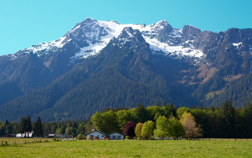
Whitehorse Mountain
Above the Sauk River valley, Darrington, WA
Population
About 1,520 people (WA OFM estimate, April 1, 2026), up from 1,462 at the 2020 Census
Typical commute
About 1.5 hours to Seattle; 25 to 30 minutes to Arlington on SR 530
Schools
Darrington School District, PK-12 on one shared campus
Where it sits
98241, at the east end of SR 530 on the Mountain Loop Highway
// The honest trade-offs
Relocating to Darrington: The Quick View
No town is right for everyone, and Darrington is honest about what it is. It trades suburban convenience for mountain access, space, and community. Here is the quick view, straight, so you can decide whether it fits.
Why people move here
The mountains are out the back door
Whitehorse Mountain rises right behind town, and the Mountain Loop Highway and the Sauk River put hiking, climbing, fishing, and camping minutes from home.
Real value for the dollar
Homes, large lots, and riverfront acreage cost a fraction of comparable properties on the I-5 corridor. The trade-off is distance, not quality.
A genuine small town
Around 1,500 people, a compact walkable core, and a volunteer spirit that shows up for neighbors and for the festivals that fill the summer calendar.
Space and quiet
Multi-acre parcels, forested lots, and riverfront property are normal here rather than rare. Most people own their homes and know their neighbors.
The honest trade-offs
The commutes are long
Seattle is about 1.5 hours and Everett roughly an hour away. The drive is scenic, but it is long, and SR 530 is the only highway out of town.
Fewer everyday amenities
Shopping, dining, and services are limited in town. Most day-to-day errands mean a trip to Arlington or Marysville.
Mountain weather and roads
Winters bring snow and ice at elevation, the Mountain Loop has a gravel section that closes seasonally, and the valley carries real flood and landslide history that deserves attention before you buy.
A thin local job market
Employment in town is limited, so most working residents commute out to Arlington, Everett, and beyond. The distance is easier to live with when your work does not require a daily drive out of the valley.
// The drive, honestly
Commuting from Darrington: the real numbers
Darrington sits at the east end of SR 530, and that single two-lane highway is the only year-round paved route out of town to the west. The Mountain Loop Highway heads south instead, but its gravel middle section closes every winter. The ranges below are approximate weekday figures that swing with departure time, weather, and incidents; treat them as planning numbers, not promises.
| Destination | Main route | Off-peak | Rush hour |
|---|---|---|---|
| Arlington | SR 530 west, about 22 miles | About 25 to 35 minutes | About 30 to 40 minutes behind slow vehicles or logging traffic |
| Marysville | SR 530 to I-5 south | About 40 to 50 minutes | About 50 to 70 minutes |
| Everett | SR 530 to I-5 south | About 55 to 70 minutes | About 65 to 90 minutes |
| Seattle | SR 530 to I-5 south | About 1.5 hours | About 1.5 to 2 hours; more on bad days |
| Granite Falls (scenic loop) | Mountain Loop Highway, seasonal | About 45 to 60 minutes on the summer loop | Closed in winter; the roundabout way via Arlington is about an hour and 15 minutes |
Approximate ranges drawn from WSDOT travel-time data and local commuter reports. SR 530 can flood or close during severe storms, and slow vehicles, logging trucks, and winter conditions add real time. Verify your specific route before you commit to a neighborhood.
SR 530: the only road west
SR 530 is Darrington’s lifeline to Arlington and I-5. It is scenic along the North Fork Stillaguamish, but it is two lanes with limited passing, and it has a history of flood and landslide closures, including the 2014 Oso landslide that cut the road for months. Most residents keep a fuel-buffer habit and check road alerts before winter storms.
WSDOT travel infoCommunity Transit Route 230
Route 230 is the weekday bus from Darrington to the Smokey Point Transit Center near Arlington, along SR 530 through Oso, with a limited commuter-oriented schedule of about two round trips a day. Community Transit’s on-demand Zip shuttle also serves the area for flexible trips. Most commutes are by car, but the connections exist if you plan around them.
CT in DarringtonSeasonal roads & weather
The gravel section of the Mountain Loop between Barlow Pass and Bedal typically closes at the forest gates from mid-to-late November until late May or June. Winter brings snow and ice at Darrington’s valley floor and more at the passes. All-weather or studded tires, chains in the car, and a habit of checking road alerts before storms are part of life here.
Mountain Loop status// Prices, dated and sourced
What homes cost in Darrington
There is no official Darrington median published by a public source, so start with the dated countywide number below, then read the local market qualitatively: the valley is small, inventory is thin, and a single sale can move any monthly average. The countywide figure is a dated, sourced snapshot; your exact costs depend on the address, the property, and the market on the day you buy.
City median home value
$407,378
Zillow Home Values, June 2026
City medians are a monthly snapshot, refreshed monthly, and they differ from the countywide NWMLS median.
| Measure | Darrington area | Comparison | Source |
|---|---|---|---|
| Countywide median sale price, all homes | $720,000 for September 2026, down 0.4% year over year | Darrington typically runs well below this anchor | NWMLS, Sept 2026 |
| Typical local listings | Single-family homes, many built decades ago, plus cabins, manufactured homes on owned land, acreage, and riverfront parcels | Far below the county median per square foot is common | MLS & local sales, qualitative |
| Sales pace & inventory | Low inventory and small monthly sales volume across the valley | Treat any local figure as approximate | MLS, qualitative |
| Lot sizes | Town lots to multi-acre forest and riverfront parcels; land value varies sharply with view, river, and access | Acreage is the norm beyond the town core | MLS & county, qualitative |
The countywide median of $720,000 for September 2026 is per the NWMLS market snapshot published October 6, 2026. NWMLS market snapshot
What the dollar buys
Darrington is a value market in the truest sense: the cost per square foot and per acre runs well below the I-5 corridor, and the premium listings are the riverfront and mountain-view parcels, not the houses. Many homes are older, some are cabins or manufactured homes sitting on owned land, and newer subdivision construction is rare. People come for land, views, and quiet, and that is what the dollar buys here.
How buying works here
Because inventory is thin and the market is small, the right property matters more than market timing. Rural listings carry real questions: well and septic condition, flood history, road maintenance, and the foundation story of an older house. Curt’s construction background is exactly for this, helping you tell a value from a repair project before you bid. A monthly sitewide refresh keeps these market figures current. See the county market report
// Before you make an offer
Darrington-specific things to check before you buy
The river valleys and mountain setting bring their own rules, from floodplain and slope hazards to wells, septic, and winter road maintenance. These are the checks that come up most often in Darrington and the Sauk and Stillaguamish valleys. Requirements vary by property and address, so treat this list as a starting point, not an answer for a specific lot.
Flood zones along the rivers
Darrington sits where the Sauk joins the North Fork Stillaguamish, and the valley floors flood. The December 2023 atmospheric-river storm pushed the North Fork to a 15.21-foot crest at the Arlington gage and flooded valley roads and properties upstream toward Darrington. FEMA maps a 1-percent annual chance floodplain (Zone AE with a base flood elevation near town) across parts of the valley, so confirm the parcel’s flood zone, base flood elevation, and elevation above the river before you buy.
County flood mappingWells and septic
Most of the town core runs on municipal water and sewer, but the acreage and riverfront parcels most buyers want sit outside the service area and run on private wells and on-site septic. Well yield, water quality, septic type, and maintenance and replacement costs are property-specific questions, not assumptions. Confirm the service type on the exact parcel and review records through the health district.
Snohomish Health DistrictLandslide & debris-flow awareness
The Stillaguamish valley has a documented history of slope failure: the 2014 Oso landslide destroyed the community on SR 530 and dammed the river, and steep valley walls carry landslide and debris-flow hazard along the river corridors and steep slopes. Snohomish County maps geohazard areas, so ask where the parcel sits relative to mapped slide and debris-flow zones, and get a geotechnical review before building near a steep slope or ravine.
County hazard mappingRural zoning & ADU rules
The town of Darrington has its own zoning, while the surrounding valley is unincorporated county land under Snohomish County’s rural zoning, and the two sets of rules differ: minimum lot sizes, allowed uses, and outbuilding and accessory dwelling unit (ADU) requirements are not the same. Whether you can add a second unit or a shop depends on the jurisdiction and the lot, so confirm the current zoning for any parcel before you plan improvements.
Town of DarringtonForest adjacency & wildlife
Much of the valley borders the Mount Baker-Snoqualmie National Forest and active timberlands, so logging trucks share SR 530 and the forest roads, and deer, elk, and black bear are everyday neighbors on the edges of town. Forest-adjacent properties carry wildfire risk in dry stretches, and private timber harvests on neighboring land can change views and traffic. If a property sits up a forest road, confirm access easements and road maintenance agreements.
Mt. Baker-Snoqualmie NFWinter road maintenance
Because so many Darrington properties sit on county or private roads, maintenance responsibility varies: the state plows SR 530, the county handles county roads, and some shared private lanes are maintained by the owners who live on them. Ask who maintains the road, whether it is plowed in winter, and whether a road maintenance agreement exists before you buy up a forest lane.
// Where you would actually live
Neighborhoods in and around Darrington
Darrington is a small town, so the housing story is less about distinct districts and more about how far you are from the center and which river or ridge you face. Most homes are single-family houses, many built decades ago, on lots that range from walkable town blocks to multi-acre forest parcels.
Town core
Darrington's compact center along SR 530 holds most of the town's businesses, services, and community buildings, with older single-family homes on tree-lined streets within walking distance.
Swede Heaven
The rural area east of town, served by the Darrington School District, offers larger forested parcels, a quieter pace, and a more secluded mountain setting.
Sauk River valley
Riverfront homes, cabins, and acreage line the Sauk and the North Fork Stillaguamish, with the Mountain Loop Highway running straight through the valley.
Rural acreage
Beyond the town edges, properties range from multi-acre hobby parcels to timbered lots with mountain views, the kind of land that rarely comes up closer to the freeway.
// Why most buyers look this far east
Parks, trails, and the mountains at the doorstep
Darrington is the recreation gateway of the north Cascades. Whitehorse Mountain, the Mountain Loop Highway, and the Sauk River put some of the best outdoor country in western Washington within minutes of the post office.
Whitehorse Mountain
The 6,840-foot peak that anchors the skyline is a serious mountaineering objective for experienced climbers and a landmark you see from town every day.
Mountain Loop Highway
The scenic byway links Darrington to Granite Falls through the western Cascades, with trailheads, campgrounds, and overlooks along the way. The 2026 season opened May 15, and snow at Barlow Pass closes the full loop at the forest gates each mid-to-late November.
Sauk River
A federally designated Wild and Scenic River and one of the region's best steelhead and salmon fisheries. Spring runoff brings Class III-IV rafting, and the White Chuck boat launch provides river access.
Trails and campgrounds
The 27-mile Whitehorse Trail follows an old rail grade toward Arlington. Phase 3 construction began October 5, 2026: the first three miles are closed through spring 2027 while crews stabilize a slide and resurface, and a stretch east of the Trafton Trailhead stays closed after river bank erosion, so check the county page before a ride. The easy Old Sauk Trail just gained an accessible loop, and Bedal and Squire Creek campgrounds sit minutes away; Clear Creek remains closed.
// Main Street, Darrington style
Downtown: small, walkable, and real
Downtown Darrington is a handful of blocks along SR 530 that hold the coffee shops, restaurants, and small businesses keeping the town running. The Community Center, built in 1954, has hosted the valley's gatherings for generations, and the Sauk-Suiattle Museum preserves the area's deep history.
The Bluegrass Music Park and the Timberbowl Rodeo grounds sit just west of town, which means summer in Darrington is busy with visitors, pickers, and rodeo crowds while the year-round feel stays neighborly.
Local spots to know
- Moe's Darrington Coffee shop and bar on Seeman Street
- Bespoke Café Cafe on Cascade Street
- Dos Agaves Mexican restaurant on SR 530
- River Time Brewing Brewery and kitchen on Emens Avenue
- Darrington IGA The town grocery on Seeman Street
- Pioneer Park Riverside park in the heart of town
- Darrington Ranger Station USFS office for permits, trail, and road info
// How the town works day to day
Local info: schools, events, and getting around
Schools
Darrington School District serves the town on one shared campus: Darrington Elementary and Darrington Jr/Sr High sit on Fir Street near downtown, so kids in the same family go to school in one place. Attendance is assigned by address, and homes just outside the town or district boundary can fall to a neighboring district, so confirm the assigned district and school for the exact address before you buy.
Getting around
SR 530 runs west to Arlington and I-5, and the Mountain Loop Highway heads south toward Granite Falls. The full loop is a classic summer drive, but the gravel middle section and seasonal snow mean it closes in winter. All-weather tires are part of living here.
Community character
The valley is the traditional home of the Sauk-Suiattle people, and it carries logging-town roots into a recreation economy. After the 2014 Oso landslide closed SR 530, the community pulled together to rebuild its road and its sense of home. That resilience defines the place.
Mark the calendar
Darrington Bluegrass Festival
2026 dates passed
The 49th annual festival ran July 17 to 19, 2026 at the Bluegrass Music Park, one of the Pacific Northwest's longest-running bluegrass events. The 2027 edition would be the 50th; expect dates early in the new year.
Timberbowl Rodeo
2026 dates passed
The 2026 rodeo ran June 27 to 28 at the Darrington Rodeo Grounds, a family tradition since 1962 with bull riding, bronc, and barrel racing. Look for 2027 dates early next year.
Grand Old 4th of July
2026 dates passed
The town's 2026 Independence Day celebration drew the whole valley together, as it does every July 4.
Re/Evolution: Summerjam
2026 dates passed
The 2026 multi-day music festival at the Darrington Music Park ran August 5 to 9. Summer concerts return to the park each warm season.
Holiday Bazaar at the Community Center
Upcoming this season
The Community Center's annual holiday bazaar returns this November; last year's fifth annual was November 22. Check the center's events page for this year's date.
Community center events// The honest trade-offs, city to city
How Darrington compares to its neighbors
The trade-offs around Darrington come down to one axis: how much drive you want between the mountains and the freeway. Straight reads, no marketing.
vs. Arlington
Arlington is the county’s north-side hub: I-5 access, full retail, Cascade Valley Hospital, and a much shorter drive to Everett and Seattle. You trade Darrington’s mountains-out-the-back-door for real convenience, but both towns sit on the same road, so the choice is really about how much of SR 530 you want in your daily life.
Read the Arlington guidevs. Granite Falls
Granite Falls is the other Mountain Loop town, but it sits roughly 30 miles closer to Everett, with more services, more new subdivisions, and a larger school district, while still keeping forest access. Darrington is deeper in the mountains, quieter, and tends to cost less per acre, at the price of a longer, more weather-dependent commute. In summer the scenic loop connects the two; in winter the drive goes the long way around via Arlington.
Read the Granite Falls guidevs. Oso
Oso is a tiny rural community on SR 530 between Darrington and Arlington, with almost no services of its own and a deep, sobering history after the 2014 landslide. It offers big lots and quiet in the same valley for buyers who want Darrington’s setting with a shorter drive to town, but you give up even more of the small-town conveniences, including a true town center.
// Day-to-day life
Everyday life in Darrington
Shopping & services
The Darrington IGA covers the daily grocery run, and the handful of shops, restaurants, and espresso stands on the main blocks handle the basics, but the real retail and service trips go to Arlington or Marysville, roughly 25 to 50 minutes down SR 530. Most households plan errands in batches, and that is simply the rhythm of life here.
Healthcare
Skagit Regional Health’s Darrington Family Medicine on Riddle Street provides family medicine as a rural health clinic, and the Sauk-Suiattle Indian Tribe Health Clinic also serves the community. The nearest emergency department is Cascade Valley Hospital in Arlington, about 25 to 35 minutes down SR 530, with Providence Regional Medical Center in Everett for the largest regional care.
Darrington Family MedicineLibrary & community
The Sno-Isle Darrington Library on Cascade Street anchors programs, computers, and wifi, and the Community Center hosts the gatherings that hold the town together. The summer calendar is the centerpiece: the Darrington Bluegrass Festival in July, the Timberbowl Rodeo in June, the Grand Old 4th, and summer concerts at the music park.
Darrington Library// Darrington relocation FAQ
Questions people ask about Darrington
These are the Darrington-specific questions Curt hears from buyers weighing a move. The countywide questions, on rates, equity, and selling first, live on the countywide relocation guide and the main FAQ page.
01 Is Darrington really as remote as it sounds?
Yes, in the ways that matter to commuters. SR 530 is the only year-round paved route west to Arlington and I-5, and the Mountain Loop heads south only seasonally. The town covers daily essentials, but most shopping, services, and jobs are a drive away. That distance is exactly what some buyers want, and exactly what others cannot live with, so the commute is the first thing to test before you fall for the scenery.
02 What is the commute to Everett or Seattle actually like?
Approximate and variable. Arlington runs about 25 to 35 minutes down SR 530, Everett about 55 to 70 minutes, and Seattle about 1.5 hours, with rush hour, logging traffic, and winter weather adding time. Community Transit Route 230 runs a limited weekday schedule to the Smokey Point Transit Center, and the on-demand Zip shuttle serves the area, but most residents drive. Test the drive at the time of day you would actually make it.
03 When does the Mountain Loop Highway close, and what about SR 530 in winter?
The gravel section between Barlow Pass and Bedal typically closes at the forest gates from mid-to-late November through late May or June. SR 530 itself stays open year-round, but it can flood or close during severe storms, as the 2014 Oso landslide showed when it cut the road for months. All-weather tires, chains, and a habit of checking road alerts before winter storms are part of living here.
04 Should I worry about flood and landslide risk in the valley?
It deserves real diligence. The Sauk and the North Fork Stillaguamish flood, with December 2023 as the most recent major example, and FEMA maps a floodplain across parts of the valley. Steep valley walls also carry landslide and debris-flow hazard, with the 2014 Oso slide the region's worst example. Requirements vary by property: check the parcel's flood zone, geohazard location, and elevation before you commit.
05 What kinds of homes and lots will I find?
Mostly older single-family homes, plus cabins and manufactured homes on owned land, and multi-acre or riverfront parcels that rarely come up closer to the freeway. Newer subdivision construction is rare. The town core has municipal water and sewer; outlying properties run on wells and septic. Expect to budget for the systems and upkeep of an older rural home.
06 What about utilities, internet, and cell service?
The town core has water, sewer, and broadband service, but outlying acreage often runs on wells, septic, and whatever internet and cell coverage the specific location offers, which varies widely up the valleys. Test the signal and confirm each utility for the exact address before you commit to a property.
07 What is there to do in winter?
The mountains do not close. Snowshoeing and winter hiking start right at the Mountain Loop gates, river fishing continues in the valley, and the town keeps a community calendar running through the dark months. The trade-off is that the long scenic drives of summer become shorter, closer-in outings, and trips out to Arlington and Marysville need a weather check.
Still deciding?
Curt has sold all over Snohomish County since 2003 and knows the Sauk and Stillaguamish valleys street by street. Ask him your specific question, free and pressure-free.
// Darrington, current and verified
News and updates from the valley
What is changing in Darrington right now, from the market to trail projects and town business. Curt updates this from Snohomish County’s project pages, NWMLS market data, the Mount Baker-Snoqualmie National Forest, and the town’s council records, so residents and buyers get the current version of the story, not last year’s.
Last refreshed October 22, 2026. Coming up next: the Community Center’s annual Holiday Bazaar in November, and 2027 dates for the Bluegrass Festival, Timberbowl Rodeo, and Summerjam.
Market update / October 22, 2026
Darrington Market Update: What the Fall 2026 Numbers Show
Darrington’s median runs in the low $500,000s on a very thin sample, countywide inventory is up sharply, and a new half-percent local excise tax took effect for sales in town. Here is what the numbers actually mean for buyers and sellers right now.
Read the full updateAround town / October 22, 2026
What’s New in Darrington This Fall: Trail Work, the Mountain Loop, and Town Business
Whitehorse Trail Phase 3 construction closes the first three miles through spring 2027, the Mountain Loop’s 2026 season is winding down, Clear Creek Campground stays closed, and the town council has had a busy year on budgets, taxes, and the books.
Read what’s new// Curt covers the whole county
Thinking about Darrington?
Curt has sold real estate across Snohomish County since 2003, and he knows what the mountain communities offer that the I-5 corridor does not. He will give you the honest read on Darrington: the value, the commute, the roads, and whether it actually fits how you live.
Darrington sits in ZIP 98241, about 25 to 30 minutes east of Arlington on SR 530. Ask Curt about riverfront, acreage, and mountain-view properties currently on the market in the Sauk River valley.