
// River town · Antique Capital of the Northwest
Snohomish
The county’s heritage river town, where a National Register downtown meets the Centennial Trail.
Snohomish is the county’s heritage town. Settled in 1859 as a river landing and mill town, it became the first incorporated city in Snohomish County in 1890 and kept the county seat until 1897. Today it is best known for a 26-block historic district along the Snohomish River, antique shops that line First Street, and the Centennial Trail running right through town. This guide covers Snohomish’s neighborhoods, parks, downtown, schools, and the real estate picture for anyone considering a move here.
Video: A drive down 1st Street in Snohomish
Video by Curt Simmons
Population
About 10,700 residents (Census estimate, July 2025: 10,719); 2020 Census: 10,126
Typical commute
About 15 to 30 minutes to Everett via US-2; 50 to 90 minutes to Seattle at peak
Schools
Snohomish School District serves the city, with Snohomish High and Glacier Peak High
Where it sits
ZIP 98290, on the Snohomish River about 25 miles north of Seattle, just east of I-5
// The honest trade-offs
Relocating to Snohomish: The Quick View
No town is right for everyone, and Snohomish is honest about what it is. It delivers a walkable historic downtown, the trail system, and some of the most characterful housing in the county, and it asks you to trade freeway convenience and big-box proximity in return. Here is the quick view, straight, so you can decide whether it fits.
Why people move here
The best-preserved downtown in the county
A 26-block historic district on the National Register of Historic Places, with red-brick storefronts, false-front buildings, and the antique shops on First Street that earned Snohomish the nickname Antique Capital of the Northwest.
The Centennial Trail runs through town
The 30-mile paved rail-trail has its southern trailhead right in Snohomish at First Street, and it connects the town to Lake Stevens and Arlington for biking, running, walking, and even horseback riding.
A real river town
Cady Park puts a boat launch on the Snohomish River, the Riverfront Trail follows the north bank, and kayaks and paddleboards are a normal sight on the water through downtown.
Character homes that kept their feel
Because Snohomish grew more slowly off the I-5 corridor, the older neighborhoods near downtown kept their original character instead of being rebuilt over.
The honest trade-offs
No direct I-5
The town sits east of the freeway on US-2 and Highway 9, so commutes to Everett and Seattle take a little longer than in the I-5 corridor towns.
Tourist crowds downtown
Weekends bring antique shoppers, and Kla Ha Ya Days and the summer event calendar pack First Street, which is good for the town and a factor if you live right downtown.
Most everyday shopping is a short drive
Big-box retail, groceries, and the widest dining options sit along the highway or in Everett, Mill Creek, and Marysville a short drive away.
Older homes need upkeep
Much of the housing stock is historic, so maintenance and upgrades are part of the deal, and a builder\u2019s eye goes a long way when you are budgeting a purchase.
// The commute, honestly
Commuting from Snohomish: the honest picture
Snohomish sits east of I-5 at the junction of US-2 and Highway 9, which means the town keeps its calm character and you trade some freeway convenience in return. The ranges below are approximate weekday figures that swing with departure time, weather, and incidents; treat them as planning numbers, not promises.
| Destination | Main route | Off-peak | Rush hour |
|---|---|---|---|
| Everett | US-2 west across the trestle | About 15 to 20 minutes | About 20 to 30 minutes in the worst of it |
| Seattle | US-2 to SR-522, or Highway 9 to I-5 | About 35 to 45 minutes | About 50 to 90 minutes |
| Bellevue | Highway 9 south to I-405 | About 35 to 40 minutes | About 50 to 90 minutes |
| Redmond / Eastside tech | Highway 9 to I-405 to SR-520 | About 40 to 45 minutes | About 60 to 90 minutes |
| Boeing / Paine Field | US-2 west to SR-526 | About 25 to 30 minutes | About 35 to 45 minutes at shift change |
Approximate ranges drawn from WSDOT travel-time data and local commuter reports. The US-2 trestle, Highway 9, and the SR-522 squeeze near Bothell add the most time at peak. Verify your specific route before you commit to a neighborhood.
Highway 9 & US-2
Highway 9 is the two-lane north-south spine that backs up at peak, and the US-2 trestle is the Everett chokepoint. Relief is on the way: WSDOT began widening Highway 9 near Snohomish in late 2025, adding a new river bridge and two lanes each way from Marsh Road to 2nd Street, and the trestle replacement is still in study.
SR-9 wideningCommunity Transit
The Snohomish Park & Ride is on Community Transit Route 908 to downtown Bellevue on weekday peaks, via the Monroe and Bothell park-and-rides, and local routes link the town to Everett Station and Ash Way in Lynnwood, where Sounder and Link connections wait.
CT in SnohomishLink & Sounder
Link’s 1 Line reached Lynnwood City Center on August 30, 2024, about 15 minutes west on I-5, and Sounder runs from Everett Station, about 59 minutes to Seattle King Street on weekdays. There is no rail stop in town itself, so most residents drive or bus to a station. The planned Everett Link extension is on track for around 2037 to 2041.
Everett Link status// Prices, dated and sourced
What homes cost in Snohomish
Snohomish is a character market, and the median reflects the historic core’s premium. The figures below are dated, sourced snapshots; your exact costs depend on the neighborhood, the property, and the market on the day you buy.
City median home value
$891,252
Zillow Home Values, August 2026
City medians are a monthly snapshot, refreshed monthly, and they differ from the countywide NWMLS median.
| Measure | Snohomish | Comparison | Source |
|---|---|---|---|
| Median sale price, all homes | Typical 2026 sales have run near or slightly above the county-wide median | Near or slightly above the county-wide median of about $720,000 | Qualitative, MLS sales data |
| Typical housing type | Character homes in the historic core; newer construction around Cathcart and Seattle Hill; rural acreage toward Machias and the Pilchuck hillsides | The historic core carries the premium | MLS & city data, qualitative |
| Typical lot size | Smaller lots near downtown; subdivision lots out toward Cathcart and Seattle Hill; acreage east and south | Lots grow heading away from the river | MLS & city data, qualitative |
| HOA prevalence | Common in newer subdivisions; rare in the historic core | Varies widely by neighborhood | Disclosed per property |
County-wide median of about $720,000 for September 2026 is per the NWMLS market snapshot published October 6, 2026. NWMLS market snapshot
What the dollar buys
The historic core near downtown commands a premium for character and walkability, while newer single-family homes in the Cathcart and Seattle Hill areas deliver more square footage for the dollar, and rural acreage toward Machias and the Pilchuck hillsides trades convenience for space. Because the town grew slowly, the older stock kept its feel, and buyers pay for that.
How buying works here
Character homes always come with questions about condition, systems, and what is worth fixing before a sale, which is where Curt’s construction background earns its keep. In-demand historic streets still draw quick offers, so knowing the right number ahead of time is the advantage in a market this tight.
// Before you make an offer
Snohomish-specific things to check before you buy
A river floodplain, a National Register historic district, and rural edges give Snohomish its own set of checks. These are the ones that come up most often. Requirements vary by property and address, so treat this list as a starting point, not an answer for a specific lot.
Flood zones on the river
The Snohomish River floodplain is mapped in FEMA flood zones, and new or substantially improved homes in the 1-percent floodplain must build at least one foot above base flood elevation under the city’s code. Look up the address on the FEMA Flood Map Service Center and the city’s flood chapter before you buy.
FEMA flood mapHistoric district design review
In the 26-block historic district, exterior changes, new construction, and demolition go through design review to preserve the district’s look. Inside the home you have broad freedom, but outside, match your plans to the design standards before you buy.
Historic districtADUs
The city allows up to two accessory dwelling units per lot, attached and/or detached, with detached units capped at about 1,000 square feet and parking and permit requirements. An ADU on a floodplain or historic property must also clear those rules, so confirm both before planning.
City ADU FAQSeptic and wells
The historic core is on city utilities, but rural edges, including Machias, Cathcart, Fobes Hill, and the Pilchuck areas, can run on private wells and on-site septic. Confirm the service type on the exact parcel and review rules through the health district.
Snohomish Health DistrictSeismic & riverbank
The region is seismically active, and older homes in particular may benefit from foundation and seismic-retrofit review. Riverbank and floodplain properties can carry erosion and channel-migration considerations, so a thorough inspection should cover the ground as well as the house.
Ask about the specific lot
Flood, historic, and septic rules all come down to the exact parcel. Curt runs these checks for every buyer and can tell you what applies to a property before you spend money on it.
Ask Curt about a property// Where you would actually live
Neighborhoods in and around Snohomish
Snohomish’s housing story is one of contrast. There is the historic core, a walkable district of Victorian and early-1900s homes along the river, and there are the newer neighborhoods and rural roads on the town’s edges. Most homes are single-family houses, with the strongest demand for character homes near downtown and newer construction around Cathcart and Seattle Hill.
Historic downtown and the riverfront
The 26-block National Register district on First Street above the Snohomish River: Victorian and early-1900s homes, antique shops, cafes, and the Centennial Trail, with more character per square foot than anywhere else in the county.
Blackmans Lake
A 63-acre lake north of downtown just east of Highway 9, with Ferguson Park, a boat launch, and trails, ringed by an established mix of single-family homes and lakefront properties.
Fobes Hill and Pilchuck hillsides
Northwest of downtown, Fobes Hill offers large lots with valley and mountain views; east of town, the Pilchuck hillsides bring forested lots and a quiet foothills feel.
Cathcart, Machias, and Seattle Hill
The growing south and east edges of the 98290 area, from newer subdivisions around Cathcart and Seattle Hill to the rural, equestrian-friendly roads of Machias near the Pilchuck River.
// Trails, river, and forest
Parks, the river, and room to play
Snohomish is built for being outside. A 30-mile rail-trail starts in town, the Snohomish River runs through the middle of it, and county forest and mountain recreation sit a short drive away. You can go from a paddle launch downtown to a mountain-bike loop in the north county without much of a drive.
Centennial Trail
A 30-mile paved National Recreation Trail following an old rail grade. The southern trailhead in Snohomish sits at First Street near Cady Park, with parking nearby, and the trail runs north through Lake Stevens to Arlington.
Cady Park and the Riverfront Trail
Cady Park is the riverfront launch: a boat launch, kayak rack, fishing, and picnic spots, with the paved Riverfront Trail running along the north bank of the Snohomish River between Avenue D and the park.
The Snohomish River
The river through town is the outdoor centerpiece: kayaking, canoeing, and paddleboarding on the water trail, fishing, and slow stretches that are perfect for a family float on a summer afternoon.
Lord Hill Park
Snohomish County’s large regional park on the ridge east of town: more than 1,400 forested acres with miles of hiking and mountain-bike trails winding through woods and wetlands, plus equestrian routes, ponds, and views across the Snohomish River valley.
Mountain biking at Lord Hill Park, a walk with Jet on the Centennial Trail, and kayaking on Flowing Lake, just a few of the ways locals get outside around Snohomish
Video by Curt Simmons
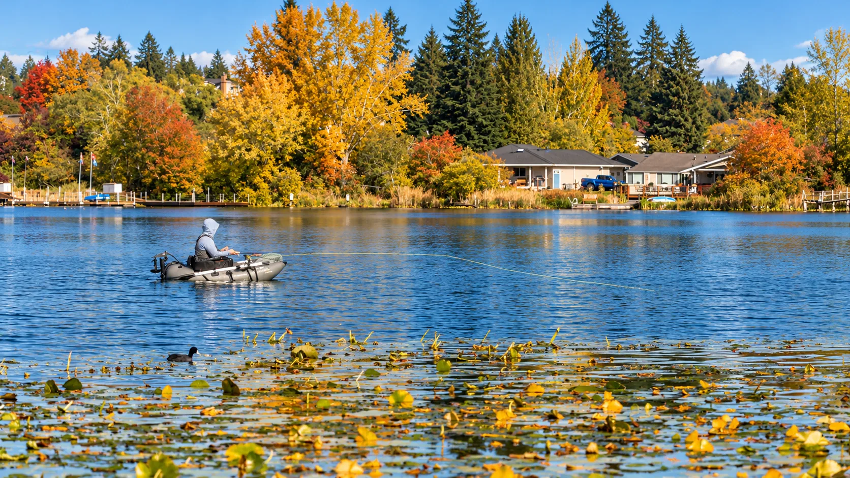
Blackmans Lake in autumn
Blackmans Lake, a short drive north of downtown where locals fish from small boats in the fall
Photo by Curt Simmons
A drone view of the bridge over the Snohomish River
Video by Curt Simmons
// Antique Capital of the Northwest
Downtown: a National Register main street on the river
Snohomish began in 1859 as a river landing and mill town, incorporated in 1890 as the first city in Snohomish County, and kept the county seat until 1897. The historic district along First Street was the first downtown historic district designated in the state, in 1973, and was listed on the National Register of Historic Places in 1974. Red-brick storefronts, Western false-front facades, and the Oxford Saloon, a former grocery dating to 1890, still line the street today.
First Street is compact and walkable, with more than 175 antique dealers packed into about a square mile and landmarks like the Star Center Antique Mall anchoring the block. Fridays on First brings live music and food in summer, Kla Ha Ya Days fills the street every July, and the Carnegie Building, a 1910 library, hosts markets and events through the year.
Local spots to know
- Star Center Antique Mall The big antique mall, 200+ dealers, on 2nd Street
- Oxford Saloon Historic First Street saloon, dating to 1890
- Proper Joe Coffeehouse Coffee shop on First Street
- Snohomish Bakery Bakery and cafe at First and Union
- Grilla Bites Co-op Cafe Co-op cafe on First Street
- Visible Coffee Roasters Coffee roaster and cafe on First Street
- Cabbage Patch Longtime downtown restaurant on Avenue A
- Java Haus Cafe Cafe on 2nd Street
A drive down 1st Street in Snohomish
Video by Curt Simmons
// The honest trade-offs, city to city
How Snohomish compares to its neighbors
Snohomish is the heritage town, and the honest comparisons run against the growing towns around it. Straight reads, no marketing.
vs. Monroe
Monroe to the east is a growing Skykomish Valley town with more new construction and generally lower prices, plus EvergreenHealth Monroe for local care. Snohomish brings the National Register downtown, the river, and the Centennial Trail, and it charges a character premium for them. If you want history and walkability, Snohomish; if you want newer homes at a lower entry, Monroe.
Read the Monroe guidevs. Lake Stevens
Lake Stevens is bigger, newer, and lake-centered, with newer subdivisions, public shoreline, and schools that grew with the boom. Snohomish is smaller with a walkable historic core, the Centennial Trail, and pricier character homes per square foot. Pick Lake Stevens for the lake and the newer build; pick Snohomish for the river-town character.
Read the Lake Stevens guidevs. Everett
Everett is the county’s urban, waterfront, transit-connected center: jobs, Sounder rail, the arena. Snohomish trades that for a small-town historic character, the river, and a quieter street life, with no rail stop in town and a longer commute to Seattle. If you want culture and transit, Everett; if you want the heritage village, Snohomish. Marysville, to the north, is the value-and-new-construction option on the I-5 corridor.
// Day-to-day life
Everyday life in Snohomish
Shopping & dining
First Street packs antique dealers, cafes, and the Oxford Saloon into a walkable stretch, and the big-box groceries and retail are a short drive to the highway corridor, Everett, Mill Creek, or Marysville. The farmers market runs in season, and Fridays on First fills the street with music all summer.
City parks & recHealthcare
EvergreenHealth Monroe is the closest hospital, about 6 miles east, and Providence Regional Medical Center Everett, about 12 miles west, is the nearest full regional and trauma center. Clinics and urgent care sit on the highway corridor between town and Everett.
EvergreenHealth MonroeLibrary & community
The Sno-Isle Snohomish Library on Maple Avenue anchors the local calendar, Kla Ha Ya Days takes over the street every July, and the Carnegie Building hosts markets and events through the year. It is the rare small town with a big sense of occasion.
Snohomish LibraryA drive through historic downtown Snohomish
Video by Curt Simmons
// How the town works day to day
Local info: schools, events, and getting around
Schools
The Snohomish School District serves the city, with elementaries including Cascade View, Emerson, and Dutch Hill, Centennial and Valley View middle schools, and two high schools, Snohomish High and Glacier Peak. Attendance is assigned by address, and neighboring districts, including Everett, Lake Stevens, and Monroe, serve areas just outside the city limits, so confirm the district for the exact home. Everett Community College is the nearest college, about 7 to 8 miles west.
Getting around
US-2 and State Route 9 meet in Snohomish, with I-5 about 10 minutes west, so Everett is a 15 to 30 minute drive and Seattle about 50 to 90 minutes at peak. Community Transit serves the town, with the Snohomish Park & Ride linking to Bellevue on Route 908 and local routes to Everett and Ash Way, and most of downtown is walkable, with the Centennial Trail as the car-free route out of town.
Community character
Snohomish took its name from the Snohomish people, who have lived along this river for thousands of years. The town served as the county seat from 1861 to 1897, and its off-the-I-5 location is exactly why the historic downtown survived: growth came slower, and the preservation followed.
Mark the calendar
Kla Ha Ya Days
The town\u2019s official summer celebration, held the third weekend of July in Historic Downtown. The 2026 edition runs July 15 to 19 in its 113th year, with the Saturday parade down First Street, a street fair, carnival, kids fair, and the balloon glow at Harvey Airfield.
Fridays on First
The weekly summer series of live music, food, and shopping that fills First Street on Friday evenings through the warm months.
Snohomish Farmers Market
The seasonal market, a Saturday morning staple with local produce, crafts, and food vendors, plus winter markets through the holiday season.
// Snohomish relocation FAQ
Questions people ask about Snohomish
These are the Snohomish-specific questions Curt hears from buyers weighing a move. The county-wide questions, on rates, equity, and selling first, live on the main FAQ page.
01 Is downtown Snohomish a good place to live, or just a place to visit?
Both, honestly. The historic core is genuinely walkable, with the river, the Centennial Trail, and a full event calendar, but weekend crowds and tourist parking are part of the deal. Buyers who want quiet usually land a few blocks off First Street or on the town’s edges.
02 If I buy a character home in the historic district, what can I change?
Exterior changes, additions, and demolition in the historic district go through design review to preserve the district’s look; inside, you have far more freedom. Talk to the city’s planning department about your specific plans before you buy so there are no surprises.
03 How long is the commute to Seattle, really?
Off-peak it runs about 35 to 45 minutes, but peak can stretch to 50 to 90 minutes via US-2 and SR-522 or Highway 9 to I-5, and there is no rail stop in town. Many residents drive to Lynnwood or Ash Way for Link, or to Everett for Sounder, to make the trip more predictable.
04 Is flooding a concern along the Snohomish River?
The river floodplain is mapped in FEMA flood zones, and new construction in the 1-percent floodplain must build at least one foot above base flood elevation under the city’s code. Check the flood map for the address and ask about flood insurance history; the hillside and higher-ground neighborhoods sit outside the floodplain.
05 Are HOAs common in Snohomish?
Newer subdivisions around Cathcart and Seattle Hill often have HOAs, while the historic core and most older neighborhoods do not. HOA status is disclosed on the title report, and Curt verifies it before you commit to a property.
06 Can I really kayak and paddleboard from downtown?
Yes. Cady Park puts a boat launch and kayak racks on the Snohomish River just below First Street, and the paved Riverfront Trail follows the north bank. It is one of the town’s best assets, and it is free.
Still deciding?
Curt has sold all over Snohomish County since 2003 and knows Snohomish block by block. Ask him your specific question, free and pressure-free.
// A character market with county-wide demand
Thinking about Snohomish?
Snohomish is where character homes meet the trail system, and it is one of the most in-demand pockets of the county for that reason. In late 2026, market data put Snohomish’s median sale price around $729,000 with homes selling in about 28 days and averaging roughly two offers, while the county-wide median sat at $720,000. The historic core near downtown commands a premium, and newer single-family homes in the Cathcart and Seattle Hill areas deliver more square footage for the dollar.
Curt has sold real estate across Snohomish County since 2003 and knows Snohomish block by block: which character homes hold value, how to position a downtown home against newer inventory, and how the school districts and trail access move demand. His construction background matters here, because older homes always come with questions about condition, systems, and what is worth fixing before a sale.
Snohomish sits in ZIP 98290, about 25 miles north of Seattle on the Snohomish River, with US-2 and Highway 9 meeting in town. Ask Curt about character homes near downtown, riverfront properties, or newer single-family homes in the Cathcart and Seattle Hill areas.
More community guides