
// Mountain Loop gateway · South Fork Stillaguamish valley
Granite Falls
The foothills town where the county opens into the mountains, and the Mountain Loop Highway begins.
Granite Falls sits in Snohomish County’s eastern foothills, where the South Fork Stillaguamish and the Pilchuck River run, about 17 miles northeast of Everett. It is a small city (around 4,450 people in the city proper) that has always been the county’s foothills value play and the gateway to the Mountain Loop Highway, with some of western Washington’s best hiking, camping, and old-growth forest minutes from town. Curt has sold real estate across Snohomish County since 2003 and knows the town’s walkable core, the hillside subdivisions, and the rural foothill areas that carry real questions worth answering. This guide covers Granite Falls’ neighborhoods, parks and outdoor access, downtown, schools, commutes, and the market picture for anyone considering a move here.
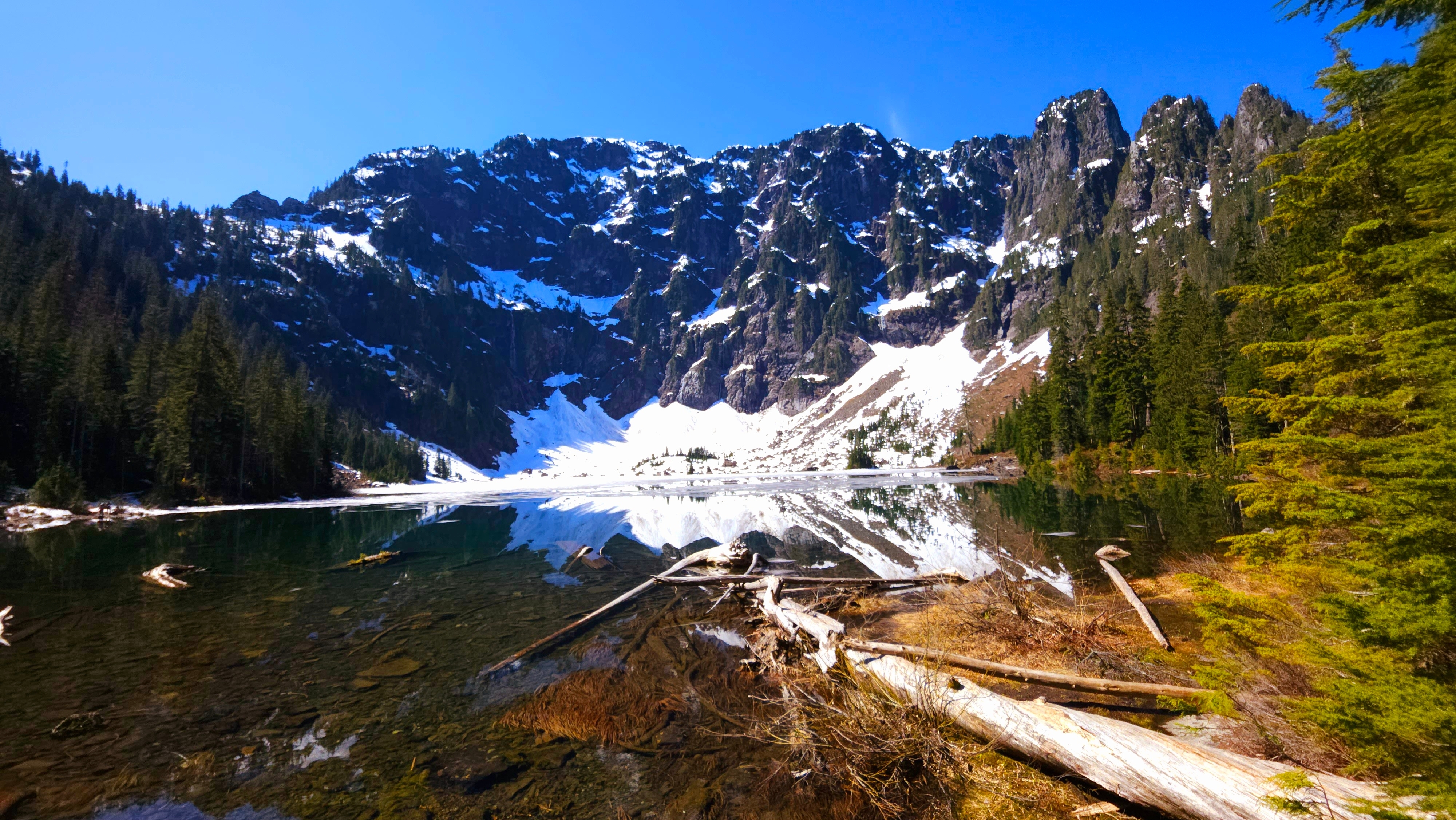
Lake 22
Lake 22, a short drive from Granite Falls on the Mountain Loop Highway
Population
About 4,765 people in the city (WA OFM estimate, April 1, 2026), up from 4,450 at the 2020 Census, with more across the surrounding foothills of ZIP 98252
Typical commute
About 25 to 35 minutes to Everett in light traffic; budget 40 to 60 minutes at peak and over an hour to Seattle
Schools
Granite Falls School District serves the city: two elementaries, a middle school, and Granite Falls High School
Where it sits
ZIP 98252, at the west end of the Mountain Loop Highway, about 17 miles northeast of Everett
// The honest trade-offs
Relocating to Granite Falls: The Quick View
No town is right for everyone, and Granite Falls is honest about what it is. It delivers foothills value, real land, and the finest outdoor access in the county at the doorstep, and it asks you to trade some commute convenience and big-city amenities for that. Here is the quick view, straight, so you can decide whether it fits.
Why people move here
The Cascade foothills start at the edge of town
Granite Falls is the official gateway to the Mountain Loop Highway, and some of western Washington’s best hiking sits minutes away: Lake 22, Heather Lake, Mount Pilchuck, and Big Four Ice Caves, plus campgrounds and rivers out the back door.
Real foothills value
Typical home values here run well below the Snohomish County median, often 20 to 30 percent lower. Buyers get more square footage, more land, and more breathing room than the same money buys on the I-5 corridor.
Space, land, and a genuine small town
The city proper is home to around 4,450 people, with larger rural lots and acreage in the surrounding foothills. It is a tight-knit community where neighbors and the local events calendar still anchor everyday life.
A compact, walkable old downtown
Stanley Street and Granite Avenue hold a real old core: local restaurants and espresso stands, an Ace hardware store, an IGA grocery, and a new civic center with a public plaza. Much of town life is within walking distance.
The honest trade-offs
The commute is the honest trade-off
Everett is about 25 to 35 minutes in light traffic, stretching to 40 to 60 minutes at peak, and Seattle is over an hour at rush hour. SR 92 is effectively the only road to the west, so a crash can close the loop.
Fewer everyday amenities in town
The IGA and local shops handle daily needs, but for the biggest retail, hospitals, and the deepest dining you head to Lake Stevens, Everett, or Marysville. Convenience is here, but the big stuff is a drive.
Foothills weather and mountain roads
Winter brings snow and ice at this elevation, the upper Mountain Loop is gravel and closes seasonally, and creek and river systems carry real flood history that deserves attention before you buy.
A small local job market
Employment in town is limited, so most working residents commute out to Everett and beyond. The drive is easier to live with when your work does not require a daily trip to the freeway corridor.
// The drive, honestly
Commuting from Granite Falls: the real numbers
Granite Falls sits at the west end of the Mountain Loop Highway, with SR 92 the single main road west to Lake Stevens and I-5. The commute to Everett is genuinely doable, and Seattle is the honest commitment. The ranges below are approximate weekday figures that swing with departure time, weather, and incidents; treat them as planning numbers, not promises.
| Destination | Main route | Off-peak | Rush hour |
|---|---|---|---|
| Lake Stevens | SR 92 west | About 10 to 15 minutes | About 15 to 25 minutes |
| Everett | SR 92 to I-5, or via Lake Stevens | About 25 to 35 minutes | About 40 to 60 minutes |
| Seattle | SR 92 to I-5 south | About 60 to 75 minutes | About 75 to 100-plus minutes |
| Bellevue / Redmond | SR 92 to I-5 to I-405 | About 65 to 80 minutes | About 80 to 110 minutes |
| Monroe | SR 92 to US-2 east | About 20 to 30 minutes | About 25 to 40 minutes |
Approximate ranges drawn from WSDOT travel-time data and local commuter reports. SR 92 can flood or close near the river crossings in severe storms, and the I-5 stretch south of Everett adds the most time at peak. Verify your specific route before you commit to a neighborhood.
SR 92: the main road west
SR 92, the Granite Falls Highway, is the primary route to Lake Stevens and I-5. It is a two-lane road that follows the South Fork Stillaguamish, and the river crossings are the weak point: in major storms the road floods near the Jordan Road and Blue Spruce areas. US-2, reached via Lake Stevens or from the south, is the practical alternate when the river is high.
WSDOT travel infoCommunity Transit Route 280
Route 280 runs seven days a week between the Granite Falls Park & Ride and Everett Station, via Lake Stevens. From Everett Station, Sounder commuter rail reaches Seattle King Street in about 59 minutes on weekdays, Sound Transit express buses cover the corridor, and the 1 Line light rail waits at Lynnwood City Center, about 15 to 20 minutes south on I-5. The bus connection makes a Seattle commute possible without driving downtown.
CT in Granite FallsMountain & winter roads
The gravel upper section of the Mountain Loop, between Barlow Pass and Bedal, typically closes at the forest gates from mid-to-late November through late May or June, and Mt. Pilchuck Road is a winter route for snowshoers at lower gates. At the foothill elevation of Granite Falls, snow and ice hit the streets a few days a year, and the river roads flood in big storms. All-weather tires and a road-alert habit keep the surprises small.
Mountain Loop status// Prices, dated and sourced
What homes cost in Granite Falls
Granite Falls has no official city median published by a public source, so start with the dated countywide number below, then read the local market qualitatively: sales here typically run below the countywide median, but the range is wide, from older town-core homes to new hilltop subdivisions to rural foothill acreage. The countywide figure is a dated, sourced snapshot; your exact costs depend on the address, the property, and the market on the day you buy.
City median home value
$538,721
Zillow Home Values, June 2026
City medians are a monthly snapshot, refreshed monthly, and they differ from the countywide NWMLS median.
| Measure | Granite Falls area | Comparison | Source |
|---|---|---|---|
| Countywide median sale price, all homes | $720,000 for September 2026, down 0.4% year over year | Granite Falls typically runs well below this anchor | NWMLS, Sept 2026 |
| Typical local sales range | Recent sales have typically run from the mid-$500,000s into the $600,000s, with individual homes and acreage well above and below | Approximate, from recent local sales, not a dated statistic | MLS & local sales, qualitative |
| Housing mix | Older character homes in the town core, newer hilltop subdivisions like Hemlock Heights and Cascadia Highlands, and rural acreage in the foothills | More new construction than deeper mountain towns | MLS & city data, qualitative |
| Sales pace & inventory | Modest inventory; listings generally sell within a few weeks to a couple of months | A close-to-balanced market | MLS, qualitative |
The countywide median of $720,000 for September 2026 is per the NWMLS market snapshot published October 6, 2026. NWMLS market snapshot
What the dollar buys
Granite Falls delivers the foothills value play: more square footage, more land, and more breathing room than the same money buys on the I-5 corridor, and typically well below the countywide median. The town core holds older character homes on walkable streets, the hilltop subdivisions carry the newest inventory, and the rural foothills trade on space and acreage. Buyers choose which trade they want.
How buying works here
Because many Granite Falls listings are rural, the checks that matter are the ones most buyers forget: well and septic condition outside the city, flood history near the rivers, foundation stories on older homes, and road maintenance on foothill lanes. Curt’s construction background is exactly for this, helping you tell a value from a repair project before you bid. A monthly sitewide refresh keeps these market figures current. See the county market report
// Before you make an offer
Granite Falls-specific things to check before you buy
Two rivers, steep foothill slopes, and a city ringed by unincorporated county land bring real property questions. These are the checks that come up most often here. Requirements vary by property and address, so treat this list as a starting point, not an answer for a specific lot.
River flood zones
Granite Falls sits where the South Fork Stillaguamish and the Pilchuck River meet, and both flood. The December 2023 storm set a record crest on the Stillaguamish, flooded around a dozen homes in town, and closed roads. FEMA maps the 100-year floodplain as Zone A along both rivers within the city, and the National Weather Service tracks the South Fork gage near town, where roughly 16 feet means Phase-3 flooding toward the Blue Spruce area and Jordan Road. Elevation and distance from the banks vary street by street.
NWS river gageCity utilities vs. wells & septic
The incorporated city runs on municipal water and sewer, but the surrounding unincorporated foothills, including the Robe and Menzel Lake areas, are on private wells and on-site septic systems. Well yield, water quality, and septic condition and replacement cost are property-specific questions. Confirm the service type on the exact parcel and review records through the Snohomish Health District.
Snohomish Health DistrictSlopes, landslides & debris flows
The foothills climb steeply out of the river valleys, and the canyon corridors of the South Fork and the Pilchuck carry landslide and debris-flow hazard along steep slopes and ravines. Snohomish County maps geohazard areas, so ask where the parcel sits relative to those zones, and get a geotechnical review before building near a steep slope, ravine, or old landslide bench.
County hazard mappingRural zoning & ADU rules
The city’s zoning governs the incorporated area, while the foothills are unincorporated county rural land with different minimum lot sizes, allowed uses, and outbuilding rules. Accessory dwelling unit (ADU) regulations also differ between the city code and the county code. Confirm the jurisdiction and current zoning for the exact parcel before planning additions or a second unit.
City of Granite FallsForest adjacency & wildlife
The Mount Baker-Snoqualmie National Forest starts east of town, and timberland and forest roads surround the foothill areas. Logging trucks use the Mountain Loop and Mt. Pilchuck Road, wildlife crosses the river roads, and forest-adjacent homes carry wildfire and tree-hazard considerations in dry stretches. If a property sits up a forest road, confirm access easements and road maintenance agreements.
Mt. Baker-Snoqualmie NFWinter & flood road conditions
SR 92 and the river roads see flooding during big storm events, upper-elevation streets get snow and ice, and the Mountain Loop’s gravel section closes every winter. The state plows the highways and the city handles its streets, but rural county roads and private foothill lanes vary in who maintains and plows them. Ask about road maintenance before buying up a foothill lane.
// Where you would actually live
Neighborhoods in and around Granite Falls
Granite Falls’ housing story runs from the walkable old core to the new subdivisions on the hillsides and the rural acreage of the surrounding foothills. The city itself is compact, roughly two square miles tucked between two rivers, and it is ringed by unincorporated county land where larger lots and well and septic are the norm. Most homes are single-family, and your address sets your school, your commute, and your utility setup.
Town core and downtown
The original plat around the commercial core on Stanley Street and Granite Avenue: older single-family homes on walkable streets, the shop fronts, City Hall, Jim Holm Park, and the schools at the center of town life.
Suncrest Farms and the east side
The city’s largest recent build-out, roughly 300-plus homes on former dairy land near Granite Falls High School, along with quiet post-war residential streets where Burn Road meets Quarry Road.
Hilltop subdivisions
Newer neighborhoods like Hemlock Heights and Cascadia Highlands sit on wooded ridgelines above town on roughly one-acre lots, with mountain and valley views and room between the homes.
Robe, Menzel Lake, and the foothills
Unincorporated rural areas east of town along the South Fork Stillaguamish: large lots, well and septic, Robe Canyon Historic Trail, and the forested corridor that leads onto the Mountain Loop Highway.
// The Mountain Loop at your door
Lake 22, the Mountain Loop, and room to play
This is Granite Falls’ defining asset. The Mountain Loop Highway begins at the edge of town, and within a short drive you reach the alpine lake, old-growth forests, and trailheads of the western Cascades. City parks, a riverside rail trail, and forest roads round out a recreation list most county towns cannot match.
Lake 22
The signature Granite Falls hike, about 5.4 miles round trip with 1,350 to 1,400 feet of gain through old-growth forest to an alpine cirque lake ringed by cliffs and waterfalls. About 13 miles east of town on the Mountain Loop (Northwest Forest Pass required), and popular in summer and on snowshoes in winter.
The Mountain Loop Highway
The scenic byway runs from Granite Falls to Darrington through the Mount Baker-Snoqualmie National Forest, with trailheads for Mount Pilchuck, Heather Lake, Big Four Ice Caves, Perry Creek, and Old Sauk along the way. The paved lower leg runs from town to Barlow Pass; the gravel middle section closes for winter.
Jim Holm Park
The lead in-town park, right across from City Hall on South Granite Avenue at the center of downtown: playgrounds, basketball courts, a renovated skate park, covered picnic areas, and open lawn. Eagle Park gives dogs an off-leash run at the east end of Stanley Street.
Frank Mason Park on Lake Gardner
The city’s lake park at the west entrance to town, off Ray Gray Road near Highway 92: a dock for fishing and swimming, picnic shelters, and a barbecue area on the shores of Lake Gardner. It is a Granite Falls park, west of the downtown core rather than one of the in-town pocket parks.
Robe Canyon and the rivers
The Robe Canyon Historic Trail follows an old rail grade along the South Fork Stillaguamish, and the river roads out of town lead to fishing, swimming holes, and forest recreation. The Pilchuck River runs along the town’s western edge.
// Stanley Street and Granite Avenue
Downtown: a compact old core, improving
Granite Falls was born of the mining boom: after gold and silver were discovered in the Monte Cristo mines to the east, the town grew fast as a supply and railroad hub in the late 1800s, then shifted to logging when the mines played out. The city incorporated in 1903 and took its name from the waterfall where the Stillaguamish River drops over granite ledges about a mile and a half east of town. It is one of the older towns in the county, and the old core still shows it.
Today downtown runs along Stanley Street and Granite Avenue: local restaurants and espresso stands, an Ace hardware store, the Market Fresh IGA, and a new civic center that opened in 2019 with a public plaza and community room. A downtown revitalization effort through the 2000s renovated buildings and added park space, and the town keeps a full events calendar around it, from the summer farmers market to Railroad Days every October. It is a small, genuine downtown built for the people who live here.
Local spots to know
- Playa Bonita Mexican Restaurant Mexican kitchen on East Stanley Street
- Omega Pizza & Pasta Pizza and pasta on South Granite Avenue
- Thai House Authentic Thai Cuisine Thai kitchen on East Stanley Street
- Hook Line & Espresso Local espresso stand on West Stanley Street
- The Stoat Coffee and community space on East Stanley Street
- Granite Falls Chamber of Commerce Community events and the local business directory
- City of Granite Falls Parks, recreation, and city services
// How the town works day to day
Local info: schools, commutes, and community
Schools
The Granite Falls School District serves the city and surrounding foothills, with roughly 2,300 students across Monte Cristo Elementary, Mountain Way Elementary, Granite Falls Middle School, and Granite Falls High School, plus an early learning center and alternative programs. High schoolers can reach Running Start through Everett Community College. Attendance is assigned by address, and homes just outside the city or district boundary fall to neighboring districts, so confirm the assigned school for the exact address before you buy.
Getting around
SR 92, the Granite Falls Highway, is the main road west, linking town to Lake Stevens and onto I-5 at Everett, while the Mountain Loop Highway heads east into the forest. Community Transit Route 280 runs seven days a week from the Granite Falls Park & Ride to Everett Station via Lake Stevens. By car, Everett is about 25 to 35 minutes in light traffic, stretching to 40 to 60 minutes at peak, and Seattle runs over an hour at rush hour. In winter storms, the river crossings on SR 92 and the upper Mountain Loop are worth checking before you leave.
Community character
The site was an ancient portage used by Coast Salish peoples long before the town, and Granite Falls grew out of the Monte Cristo mining boom and the railroad that fed it, then logging. Today the mountains set the calendar: hiking season through summer, Railroad Days every October, the Christmas tree lighting in December, and snowshoeing on the Mountain Loop in winter. It is a foothills town that still knows its neighbors.
Mark the calendar
Railroad Days
The town’s signature festival on the first Saturday in October, celebrating the mining and railroad era that built Granite Falls. The 60th annual edition runs October 3, 2026.
Farmers market
Sunday mornings through the summer bring local growers and vendors to town, with the Winter Market carrying the season through the colder months.
Show ’N Shine
The early-August classic car show lines up vintage and custom cars on the downtown streets, part of a summer calendar that also includes the spring Look What’s Local fair and the December tree lighting at City Hall.
// The honest trade-offs, city to city
How Granite Falls compares to its neighbors
Granite Falls sits between the I-5 cities and the deep mountain towns, which makes the comparisons honest: you trade convenience and services for foothill land, value, and the Mountain Loop at the door. Straight reads, no marketing. And Darrington, the other Mountain Loop town, trades an even longer drive for the deepest valley setting.
vs. Lake Stevens
Lake Stevens is the bigger, newer lake city about 15 minutes west: full shopping on 20th Street and Frontier Village, urgent care, and a fast run to Everett. Granite Falls trades the lake and the convenience for foothill land, lower prices, and the Mountain Loop at the door. Same direction of travel to work, a very different everyday feel.
Read the Lake Stevens guidevs. Monroe
Monroe sits on US-2 about 20 minutes south, with more retail, more services, and its own growth pressures, along with a large river floodplain on the Skykomish and Snohomish. Granite Falls is smaller and more rural, with the national forest at the edge instead of the US-2 corridor. Monroe has the services and the highway commute; Granite Falls has the forest and the space.
Read the Monroe guidevs. Sultan
Sultan on US-2 is farther east and smaller, with foothills similar to Granite Falls but a quieter commercial core, and its commutes run west on US-2 through Monroe toward Everett. Both are entry-points towns to the Cascades; Granite Falls has more schools, services, and the Mountain Loop highway head start, while Sultan puts you on the paved route to Stevens Pass.
Read the Sultan guideCompare Granite Falls to the other Mountain Loop town: see the Darrington guide for the deeper valley trade-off, and the countywide relocation guide for the whole-county picture.
// Day-to-day life
Everyday life in Granite Falls
Shopping & services
The Market Fresh IGA and Ace Hardware anchor daily needs on Stanley Street and Granite Avenue, with local restaurants, espresso stands, and shops a short walk away. The big retail, malls, and deepest service selection live in Lake Stevens, roughly 10 to 15 minutes west on SR 92, with Everett and Marysville a stretch further. It is a self-sufficient small town that expects the weekly trip out for the big stuff.
Healthcare
Family medicine is in town at Skagit Regional Health Granite Falls Family Medicine on West Stanley and the Granite Falls Medical Clinic on South Granite. Urgent care sits about 10 to 15 minutes away in Lake Stevens, and the nearest hospital emergency departments are Cascade Valley Hospital in Arlington and Providence Regional Medical Center in Everett, each roughly a half-hour drive.
Granite Falls Family MedicineLibrary & community
The Sno-Isle Granite Falls Library on East Galena anchors programs and events, and the civic center on the old town hall block hosts the public plaza, library hub, and community room. The calendar runs from the summer farmers market to Railroad Days each October and the December tree lighting at City Hall.
Granite Falls Library// Granite Falls relocation FAQ
Questions people ask about Granite Falls
These are the Granite Falls-specific questions Curt hears from buyers weighing a move. The countywide questions, on rates, equity, and selling first, live on the countywide relocation guide and the main FAQ page.
01 How bad is the commute to Everett or Seattle?
Approximate and variable. Everett runs about 25 to 35 minutes in light traffic and 40 to 60 minutes at peak on SR 92 to I-5. Seattle is the real commitment: about 60 to 75 minutes off-peak and 75 to 100 minutes or more at rush hour. Community Transit Route 280 runs seven days a week to Everett Station, where Sounder rail and Sound Transit express buses reach Seattle, so the transit option is real if you plan around it.
02 Is Granite Falls really at risk of flooding?
The South Fork Stillaguamish and the Pilchuck River flood, and the town has withstood repeated events: the December 2023 storm set a record crest and flooded about a dozen homes. FEMA maps the 100-year floodplain as Zone A along both rivers within the city, and the National Weather Service posts flood warnings from the gage near town. Elevation and distance from the banks vary street by street, so check the exact parcel, not just the neighborhood.
03 What are the roads like in winter?
SR 92 stays open year-round but can flood near the river crossings during severe storms, when US-2 via Lake Stevens is the practical alternate. Snow and ice hit the foothill elevation a few days a year, and the gravel upper Mountain Loop closes from around mid-November through late May or June. All-weather tires and checking road alerts before storms are the local habits.
04 What kind of housing will I find here?
The town core holds older character homes on walkable streets, the hilltop subdivisions like Hemlock Heights and Cascadia Highlands have the newest inventory on roughly one-acre wooded lots, and the rural foothills toward Robe and Menzel Lake offer larger parcels on wells and septic. Most buyers find a mix of eras, and the older and rural homes carry the most inspection questions.
05 Which school district serves Granite Falls?
The Granite Falls School District serves the city and surrounding foothills, from Monte Cristo and Mountain Way elementaries through Granite Falls Middle and Granite Falls High. Attendance is assigned by address, and homes just outside the city or district boundary fall to neighboring districts, so confirm the assigned school for the exact address before you buy.
06 Do I have to drive far for everyday needs?
No, but plan for the big trips. The Market Fresh IGA, Ace Hardware, restaurants, and espresso stands cover daily life in town, and the library and civic center fill in the rest. Full retail and the deepest services are in Lake Stevens, about 10 to 15 minutes west on SR 92, with Everett and Marysville another stretch beyond that.
07 What healthcare is close by?
Family medicine is in town at Skagit Regional Health Granite Falls Family Medicine on West Stanley and the Granite Falls Medical Clinic on South Granite. Urgent care sits about 10 to 15 minutes away in Lake Stevens, and the nearest hospital emergency departments are Cascade Valley Hospital in Arlington and Providence Regional Medical Center in Everett, each roughly a half-hour drive.
Still deciding?
Curt has sold all over Snohomish County since 2003 and knows Granite Falls street by street, from the old core to the hilltop subdivisions to the foothill acreage. Ask him your specific question, free and pressure-free.
// The foothills value market
Thinking about Granite Falls?
Granite Falls is one of the more affordable markets in Snohomish County. Countywide, the NWMLS reported a median sale price of $720,000 for September 2026, published October 6, 2026. Locally, recent sales have typically run from the mid-$500,000s into the $600,000s, well below that countywide median, though individual homes and foothill acreage span well above and below those ranges. Those local figures are approximations from recent sales, not a dated statistic, and a monthly sitewide refresh keeps market figures current. Inventory is modest and the market generally runs close to balanced.
Where you buy changes the number. The walkable town core holds older character homes, the hilltop subdivisions carry the newest inventory, and the rural foothill areas trade on space and acreage. Because many Granite Falls listings are rural, well and septic, creek and flood history, and foundation questions come up often, and they deserve straight answers before an offer.
Curt has sold real estate across Snohomish County since 2003 and knows Granite Falls’ foothills market: which school each neighborhood feeds, how the older stock compares, and how rural utility and flood questions play into value. His construction background matters here, because foothills homes come with real questions that deserve honest answers.
Granite Falls sits in ZIP 98252 at the west end of the Mountain Loop Highway, about 17 miles northeast of Everett. Ask Curt about the town core, the hilltop subdivisions, or acreage in the surrounding foothills.
More community guides